

Jaitaran
From Wikipedia, the free encyclopedia
| Jaitaran | |
| — city — | |
| Coordinates | 26°12′N 73°56′ECoordinates: 26°12′N 73°56′E |
| Country | India |
| State | Rajasthan |
| District(s) | Pali |
| Population | 22,639 (2011) |
| Sex ratio | 958 ♂/♀ |
| Time zone | IST (UTC+05:30) |
| Area • Elevation |
• 307 metres (1,007 ft) |


Contents[hide] |
[edit] Geography
Jaitaran is located at 26.2°N 73.94°E. It has an average elevation of 307 metres (1007 feet).[edit] History
Jaitaran is also known for its founder Jaita founder of Jaitaran for great battle of samel between Sher Shah Suri and Rao Maldeo Rathore and his contribution. Jaitaran is one of the beautiful places for tourism with places like Kudki (birth place meera), Bhaval temple known for goddess bhaval whose idote take two and half pack of wine fateh sagar and plane ground which separate desert and represent beginning of world's oldest mountain railway.[edit] Demographics
As of 2011 India census[1], Jaitaran had a population of 22,639. Males constitute 51% (11,564) of the population and females 49% (11,074). Jaitaran has an average literacy rate of 65.15%, lower than the national average of 74.04%: male literacy is 75.2%, and female literacy is 54.7%. In Jaitaran, 14% of the population is under 6 years of age.[edit] References
- ^ "Census of India 2001: Data from the 2001 Census, including cities, villages and towns (Provisional)". Census Commission of India. Archived from the original on 2004-06-16. Retrieved 2008-11-01.
|
||||||||
| This article related to a location in Rajasthan is a stub. You can help Wikipedia by expanding it. |
Categories:
आलणसिंह ने संवत 979 (922 AD) में मथुरा में मंदिर बनाया तथा सोने का छत्र चढ़ाया.
ददरेवा के राव बुरडकदेव के तीन बेटे समुद्रपाल, दरपाल तथा विजयपाल हुए.
राव बुरडकदेव (b. - d.1000 AD) महमूद ग़ज़नवी के आक्रमणों के विरुद्ध राजा जयपाल की मदद के लिए लाहोर गए. वहां लड़ाई में संवत 1057 (1000 AD) को वे जुझार हुए. इनकी पत्नी तेजल शेकवाल ददरेवा में तालाब के पाल पर संवत 1058 (1001 AD) में सती हुई. राव बुरडकदेव से बुरडक गोत्र निकला.
राव बुरडकदेव के बड़े पुत्र समुद्रपाल के 2 पुत्र नरपाल एवं कुसुमपाल हुए. समुद्रपाल राजा जयपाल के पुत्र आनंदपाल की मदद के लिए 'वैहिंद' (पेशावर के निकट) गए और वहां पर जुझार हुए. संवत 1067 (1010 AD) में इनकी पत्नी पुन्यानी साम्भर में सती हुई.
- Cities and towns in Pali district
- Pali district
- Rajasthan geography stubs
Jaitaran
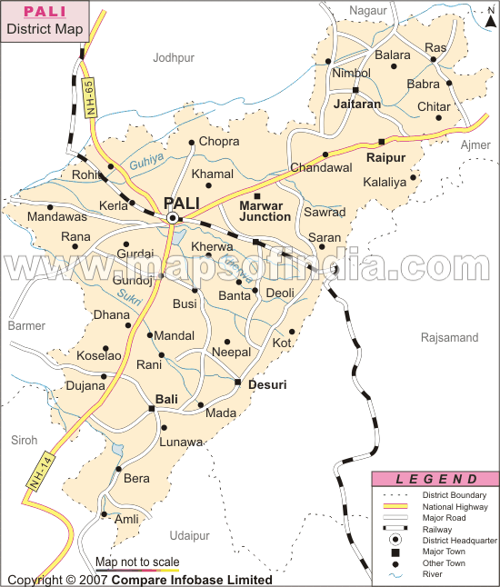
Location of Jaitaran in Pali DistrictJaitaran (जैतारण) is a tahsil town in Pali district in Rajasthan.
Location of Jaitaran in Pali District
Contents
[hide]Jat Gotras
- Bana
- Khokhar


History
बुरडक गोत्र के बडवा (भाट) श्री भवानीसिंह राव (फोन-09785459386) की बही के अभिलेखों में जैतारण का सम्बन्ध बुरड़क गोत्र के इतिहास से है. अजमेर के चौहान वंश में राजा रतनसेण के बिरमराव पुत्र हुए. बिरमराव ने अजमेर से ददरेवा आकर राज किया. संवत 1078 (1021 AD) में किला बनाया. इनके अधीन 384 गाँव थे. बिरमराव की शादी वीरभाण की बेटी जसमादेवी गढ़वाल के साथ हुई. इनसे तीन पुत्र उत्पन्न हुए:- 1. सांवत सिंह - सांवत सिंह के पुत्र मेल सिंह, उनके पुत्र राजा धंध, उनके पुत्र इंदरचंद तथा उनके पुत्र हरकरण हुए. इनके पुत्र हर्ष तथा पुत्री जीण उत्पन्न हुयी. जीणमाता कुल देवी संवत 990 (933 AD) में प्रकट हुयी.
- 2. सबल सिंह - सबलसिंह के बेटे आलणसिंह और बालणसिंह हुए. सबलसिंह ने जैतारण का किला संवत 938 (881 AD) में आसोज बदी 10 को फ़तेह किया. इनके अधीन 240 गाँव थे.
- 3. अचल सिंह -
आलणसिंह ने संवत 979 (922 AD) में मथुरा में मंदिर बनाया तथा सोने का छत्र चढ़ाया.
ददरेवा के राव बुरडकदेव के तीन बेटे समुद्रपाल, दरपाल तथा विजयपाल हुए.
राव बुरडकदेव (b. - d.1000 AD) महमूद ग़ज़नवी के आक्रमणों के विरुद्ध राजा जयपाल की मदद के लिए लाहोर गए. वहां लड़ाई में संवत 1057 (1000 AD) को वे जुझार हुए. इनकी पत्नी तेजल शेकवाल ददरेवा में तालाब के पाल पर संवत 1058 (1001 AD) में सती हुई. राव बुरडकदेव से बुरडक गोत्र निकला.
राव बुरडकदेव के बड़े पुत्र समुद्रपाल के 2 पुत्र नरपाल एवं कुसुमपाल हुए. समुद्रपाल राजा जयपाल के पुत्र आनंदपाल की मदद के लिए 'वैहिंद' (पेशावर के निकट) गए और वहां पर जुझार हुए. संवत 1067 (1010 AD) में इनकी पत्नी पुन्यानी साम्भर में सती हुई.